
LiDAR has undergone remarkable advancements in recent years, transitioning from initial bulky and expensive devices to becoming a versatile and powerful technology. Initially used in surveying and cartography, LiDAR solutions have found their way into a wide range of industries. Although it gained prominence primarily within the automotive sector as a key technology for autonomous driving, the scope of LiDAR applications and potential extends far beyond the automotive world. The laser-based technology is now reshaping and digitalizing sectors ranging from logistics and manufacturing to security and crowd management. With its distinct capabilities, LiDAR is revolutionizing the way industries operate, offering detailed 3D environmental data at the push of a button, thereby enabling smarter, safer, and more efficient solutions. This blog post discusses what these solutions look like and how companies benefit from them.
LiDAR solutions in industrial applications
- Volume Monitoring: Measuring volume in real-time
- Crowd Analytics: Analyzing and controlling people flows
- Security: Improving the reliability of security systems
- More application areas for LiDAR solutions
Measuring volume in real time
In various industries like construction, logistics, waste management, or fertilizer production, accurately measuring the volume of material piles holds significant importance. Precisely determining material volume is crucial for effective planning of purchases, production, and sales. As there’s no simple formula for irregularly shaped piles, companies often resort to manual estimations, sporadic measurements, and traditional methods like shovel or truck scales. Unfortunately, these approaches quickly hit their limitations. They usually provide only snapshot data, which is also imprecise, inevitably leading to discrepancies in inventory records.
Moreover, this manually collected volume data isn’t accessible in real-time and can’t be easily digitized, resulting in inefficient warehouse management. Low inventory levels can lead to restricted delivery capabilities or even production halts. Conversely, excessive inventory ties up capital and consumes valuable storage space.
LiDAR sensor solutions effectively address this challenge by accurately monitoring goods’ volume and seamlessly integrating the data into IT systems.
How it works:
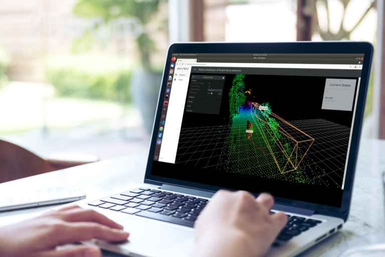
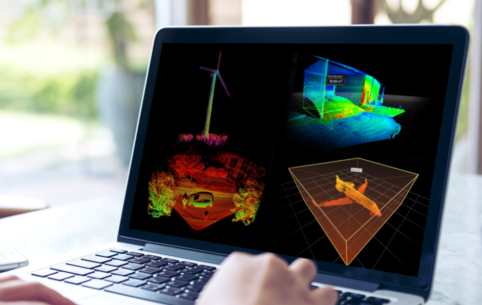
3D LiDAR sensors are strategically mounted on ceilings or masts to oversee the material piles. Thanks to their wide field of view, only a few devices are generally sufficient. They record the pile’s surface in detail and use this data to create a precise digital mesh, which is the basis for calculating the volume. The associated perception software then processes the collected data to determine the material’s volume, displaying the information in a user-friendly dashboard.
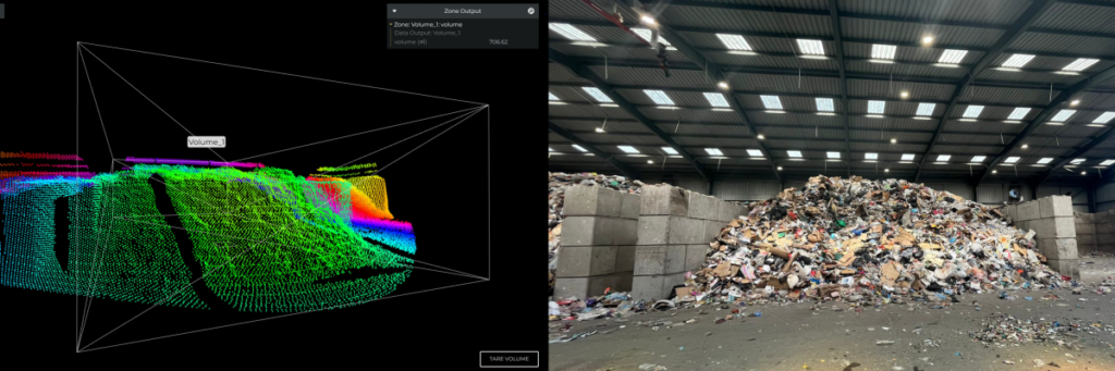
By digitizing the process, manual procedures are replaced, and companies can leverage enhanced data reliability, availability, and accuracy, along with time savings. Thanks to reliable data, inventory management can be finely tuned, thereby optimizing the entire supply chain.
More efficiency and safety in recycling
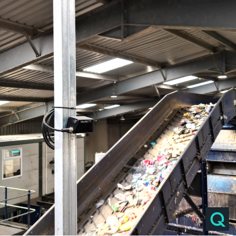
Cireco (Scotland) LLP, a leading resource management company, has partnered with volume measurement specialist Quvo Ltd to deploy Blickfeld LiDAR sensors for streamlined inventory management. Through this automated volume monitoring solution, the company is achieving precise visibility into the quantity of waste within its storage bunkers prior to sorting. The real-time data not only enhances the efficiency of the material recovery facility but also offers accounting and logistics departments a dependable information source to ensure better compliance with material storage regulations for safety and regulatory purposes.
Learn more
Analyzing and controlling people flows
However, it’s not only volumes that LiDAR solutions can capture; the technology also facilitates the counting of individuals, tracking their movements, and conducting movement analysis. Leveraging the real-time data collected, heavily trafficked areas can be utilized with greater intelligence, safety, and efficiency. This encompasses tourist destinations susceptible to overuse or large events like festivals, where rapid crowd buildup can pose risks. Even bustling transportation hubs such as airports, marked by bottlenecks and lengthy queues, frequently lack dependable real-time data to manage actively people flows.
How it works:
LiDAR solutions precisely deliver this data in 3D. Therefore, they are strategically installed to monitor critical areas, such as the security checkpoint at the airport. To accurately count the number of individuals in the queue, so-called counting zones are set up through the sensor’s linked perception software. Once a person crosses this defined area, they are counted. The dashboard then displays the exact count of individuals who have passed through the counting zone. Given the data’s three-dimensional nature, it does not capture any identifiable information about individuals within the field of view, making these sensors fitting for implementation in public spaces.
By continuously monitoring and tracking the movements of individuals, it becomes feasible to respond promptly to crowd dynamics. This capability allows for the early identification of bottlenecks, overcrowding, or potentially hazardous circumstances—such as those that can arise at festivals—and enables timely interventions to ensure safety and maintain a smooth flow. Ultimately, this leads to a more enjoyable experience for attendees.
However, data such as visitor density and behavioral patterns can serve not only for immediate control purposes but also find valuable applications in sectors like retail. For instance, it can enhance sales rates through optimized store layouts or strategic product placement.
Relaxed on vacation
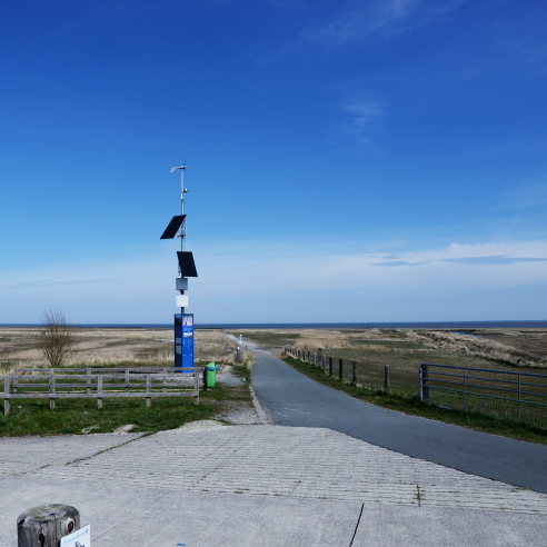
On the popular stretches of the German North Sea coast, busy beaches, crowded promenades, and parking challenges are frequently encountered during a typical summer day. In order to address these issues and provide an enjoyable experience for visitors, the umbrella marketing organization “Die Nordsee GmbH” has partnered with people counting specialist EvoCount to deploy Blickfeld LiDAR sensors. With close to 60 sensors, the organization actively monitors anonymized visitor movement in real-time. This innovative approach empowers guests to access information on the beach’s current occupancy through the website, enabling them to adjust their plans accordingly.
Learn more
Improving the reliability of alarm systems
Where and how people move also plays an important role in triggering alarms in security systems. Modern industrial facilities and critical infrastructures are constantly working on enhancing their security measures to identify and manage potential threats promptly. In this context, the significance of LiDAR-based solutions is on the rise, primarily due to their substantial reduction of false alarm occurrences in security setups. Their capacity to accurately identify trespassing objects and individuals, as well as their movement patterns, remains remarkably reliable even in low light, adverse weather conditions such as rain and snow, and challenging backlight scenarios. This capability results in a profound reduction of false alarms. The inherently three-dimensional nature of the data enables privacy-sensitive object and building monitoring, making LiDAR-based security systems suitable for use in a wide range of industries.
How it works:
LiDAR sensors are positioned to detect hazards and initiate alarms while ensuring comprehensive coverage of the monitored area. The sensors’ adaptable mounting and positioning allow for precise monitoring and effective detection in critical zones. The sensors continuously collect data and consolidate it in a point cloud. Within this point cloud, a virtual zone around objects or the designated monitoring area is set up in the associated software. When an object enters this zone and surpasses the specified size threshold, an instant alarm is triggered, promptly alerting security personnel.
By precisely detecting the size of intruding objects, LiDAR sensors prevent alarms from being triggered by small animals or branches, which often results in several false alarms per day in systems without LiDAR. The reliability of LiDAR-based security systems is therefore particularly valuable, as it prevents unwanted interruptions and unnecessary security deployments.
LiDAR sensors thus surpass conventional security solutions by delivering steadfast data accuracy across varying light and weather conditions, all while maintaining a high level of resistance to compromise or hacking attempts.
Safety first

Security is a top priority at airports. It extends beyond screening air travelers and baggage prior to departure, encompassing the safeguarding of parked aircraft against tampering and unauthorized access. LiDAR-based security solutions come into play here. They promptly activate an alarm when individuals approach an aircraft and breach a predefined virtual protection zone. The three-dimensional LiDAR data remains unaffected by darkness and adverse weather, resulting in a reduction of false alarms.
Learn more
More application areas for LiDAR solutions
In addition, there are a variety of applications of LiDAR sensors that enable more efficient and digital solutions. Take agriculture, for instance, where these sensors contribute to the automation and autonomous navigation of farming machinery while also facilitating the identification of environmental conditions and tasks like seeding and fertilization. The sensors are frequently incorporated into drones for this purpose, capturing real-time data during flight and supplanting manual procedures. However, the significance of drones equipped with LiDAR sensors extends beyond agriculture, notably in logistics, particularly concerning the challenging “last mile delivery.” This stage, marked by notably high costs, stands to significantly benefit from the digitized approach involving drones and LiDAR, enabling more efficient and environmentally conscious solutions.
Digital transformation with LiDAR solutions
The success of companies today depends to a large extent on the data they have and how smartly they use it. This development opens up completely new business fields and application areas, which are enabled and driven by technologies such as LiDAR. At the same time, the acquisition, analysis, and use of data also play a crucial role in the success of traditional industries. Choosing the right technologies is a key factor in the long-term competitiveness of companies. The ability to provide accurate and comprehensive 3D data in real-time makes LiDAR a valuable tool for companies looking for more efficient and secure solutions. With the increasing importance of data, LiDAR solutions will play a key role in the future of the industry, enabling new business models and setting the course for a successful digital future.