
To create a more attractive skiing experience, skiing area operators face several challenges. Overcrowded parking lots, full slopes, and long queues at the lift have the potential to annoy and ultimately scare off tourists during the peak season. In addition, society’s leisure behavior is becoming increasingly demanding, with new communication channels that strongly influence how we collect information, make decisions, and book activities, experiences, or accommodations. To meet these challenges and remain competitive as a skiing area, processes need to work well, and the changing needs of winter sports enthusiasts have to be addressed through new and digital solutions.
The introduction of mobile and online ticketing, apps with GPS tracking, or digital guest cards have been the first steps toward digitalization. However, there is still a lot of potential and need for action in implementing new technologies. The Corona pandemic in particular has brought this to light: Visitor limits and distance regulations, for example, have put existing visitor guidance concepts to the test and highlighted the need for new approaches. So, what can new solutions in skiing areas that help enhance the visitor experience look like, and what role can LiDAR play in this?
What is visitor management?
Visitor management refers to measures to regulate visitor flows in terms of their spatial, temporal, and quantitative distribution within the capacities of a tourist region. The aim is to create a balance between guests and locals as well as nature. The basis for a successful implementation is comprehensive real-time information on the number of visitors as well as their movements and behavior in the destination area.
Relaxed skiing: optimization through accurate data
The skiing experience for guests begins with their arrival at the skiing area. Some ski resorts do not have sufficient parking facilities for visitors due to the geographical conditions or deliberately restrict access to promote a more environmentally friendly journey and prevent congestion during peak times. In these cases, operators use bus shuttles, the so-called “ski buses,” which transport guests back and forth between the valley and the skiing area free of charge. It is essential that the arrival and departure run smoothly: Overcrowded buses or long waiting times can cause discontent and negatively influence satisfaction so that winter sports enthusiasts may choose a different area for their next ski trip.
For the skiing area, this guest transport involves a great deal of organizational and financial effort. To make the process more effective and as efficient as possible, the operators need to have reliable information about how many people are transported and on-site daily. That way they can ensure that enough buses are running or that the chartered buses are also being used to capacity. But how do skiing area operators get reliable information on bus utilization?
LiDAR enables people counting
Until now, counting has mostly been done manually by the bus drivers, which on the one hand means additional effort for them and, on the other hand, is a source of errors, e.g. when many people get on and off the bus at the front and back at the same time. Therefore, there are already different efforts to use sensor technologies that can take over the task of passenger counting, like cameras for example. They generate a video feed but require object recognition software to detect and count people. Such an intermediate step always holds the potential for errors and requires heavy computing power. Weather conditions also play a crucial role, as image quality can quickly be compromised in darkness or precipitation. Moreover, as soon as people are detected, personal data can be recorded and stored, which can quickly lead to data protection violations. The alternative use of radar sensors also has weaknesses, as the resolution here is often insufficient to distinguish objects from one another or classify them.
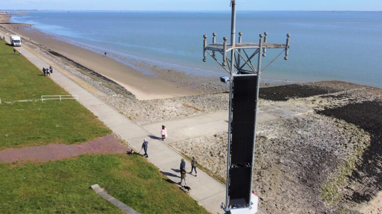
Luckily, LiDAR technology provides a solution. The laser-based sensors reliably generate data displayed in a 3D point cloud and reproduce an exact image of the surroundings in real time. To do this, a LiDAR sensor is integrated into the bus parking lot’s existing infrastructure, like a lamppost for example. It is essential that the critical area, i.e., the arrival and departure area of the buses, is covered.
To now count how many people get off the bus, so-called counting zones are set up in the point cloud with the help of the corresponding perception software. As soon as a person gets off the bus, they are detected as an object within the point cloud and counted when leaving the zone. The dashboard then displays the absolute number of people who have passed through the counting zone. Thanks to the nature of the 3D point cloud data, no conclusions can be drawn about the individual persons in the field of view, leaving their privacy consequently protected. Even in snowfall, fog, or darkness, the LiDAR sensor can easily detect guests.
Operators thus learn how many people arrive at the skiing area per trip in real-time. Based on this information, they can act more agilely and optimize their operations, e.g., by adjusting bus schedules or controlling the size and number of buses more effectively. This ultimately has a positive impact on visitor satisfaction and has the potential for cost optimization if, for example, fewer buses are needed.
Optimization of slope occupancy and waiting times
But there are not only applications for LiDAR in visitor counting for bus shuttles. Peter Hartl is an expert in GIS (Geographical Information Systems) and GPS services and managing director of Hartl Consulting, a planning office for mountain railroads, ski resorts, and tourism organizations. He has worked with skiing areas for many years and sees great potential in LiDAR technology for digitization projects.
“The sensor technology is also suitable for analyzing movement flows in the skiing area, as recording and counting people is always challenging. Particularly interesting is the counting of winter athletes at the valley stations to control the utilization of the lifts better,” says Hartl. Especially in large ski resorts, popular slopes are heavily frequented during the peak season, which means that visitors are often faced with long waiting times at the lift, which can have a negative impact on the guest experience. So, what exactly could people counting at a lift look like?
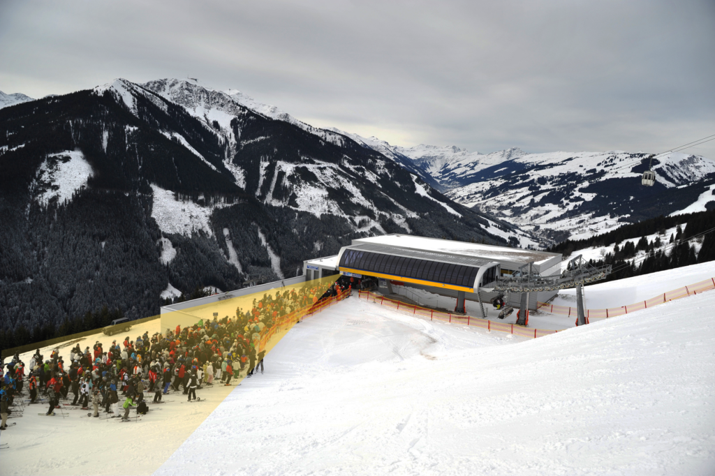
For the detection of people waiting at the lift, LiDAR sensors are mounted at the bottom station in such a way that they can overlook the arrival area of the skiers and snowboarders. Similar to the installation in the bus parking lot, a zone is defined in which the objects detected as people are counted anonymously. The operator can thus see in real-time and regardless of the weather exactly how many people are waiting in line in front of the station and calculate the waiting time based on this data. This can then be displayed, for example, in the app of the ski resort, directly at the station and/or on the lift plans. For winter sports enthusiasts, this is important information that they can use, for example, to decide which slope to choose for the next descent. The operators thus offer skiers and snowboarders an additional service that can have a positive influence on the overall experience. At the same time, they are working with a reliable source of data that enables the operators to control better the utilization of the slopes and lifts as well as visitor management. In addition, Peter Hartl adds that the data obtained through LiDAR can also be used for the maintenance and safety of the slopes.
Digitization in skiing areas
LiDAR technology can significantly support tourist destinations in making processes more efficient and the guest experience more attractive while increasing competitiveness. In particular, real-time data can be used to manage intelligently and control visitor flows in high-traffic areas such as skiing areas or coastal regions, which is an important approach for responsible and regulated tourism. The strategic use of new technology solutions such as LiDAR is therefore essential for the future of tourism and enables digitization to take an important step forward.